
World Trail Majors: 9 Ultramarathons For Your Bucket List
In November 2023 the World Trail Majors was born – a collection of nine ultramarathons across the globe selected for both for their individuality and spectacular scenery.
To meet the criteria of the World Trail Majors, it was essential that these races were developed with a respect and care for the environment at the summit of their vision – allowing runners to get closer to the raw challenge presented by nature, while preserving its health and beauty now and in the future.
The World Trail Majors values of conservation, diversity and respect – both for natural ecosystems and local cultures – form the backbone of this association. With a shared philosophy that preserves the uniqueness of each race and its character, it’s an inspiring journey to be a part of.
Join us to discover 9 of the best ultra runs and trail races across the globe – the Hong Kong 100 Ultramarathon, Black Canyon Ultra 100km, the North Face Transgrancanaria, Mt. Fuji 100, Madeira Island Ultra-Trail (MIUT), Swiss Canyon Trail, South Downs Way 100, Quebec Mega Trail and RMB Ultra-Trail Cape Town.
Every race is invigorating and challenging in its own right – with a unique identity worthy of your bucket list and that builds on the philosophy the World Trail Majors stands for.
The races are enriched by the individuality of its participants – attracting both amateur runners and elite competitors from across the globe. Many of these prestigious ultra marathons, spanning over 100km long, are part of larger running festivals, consisting of a variety of distances to cater to runners of every ability. For the purpose of this article, we’ll be focusing on the longest day or multi-day races, being the most iconic and prestigious events.
Many of these world-class trail runs traverse environments with historical significance, connecting the competitors and adventure seekers of today, to those that travelled these paths potentially centuries ago.
Whether you compete in one race or all 9, it’s an absolute privilege and thrill to be a part of the World Trail Majors legacy and the inclusive, inspirational outlook this association cultivates. Your personal journey across these rugged and serene landscapes can be life-changing as you discover your mental fortitude and inner strength on the way to the finish line.
We’ll do a breakdown of each ultramarathon – highlighting both the beauty and adversity it represents and give you a snapshot of these incredible courses.
Please consider this article as your World Trail Majors inspiration rather than your race guide, as both the course details and conditions are variable to change.
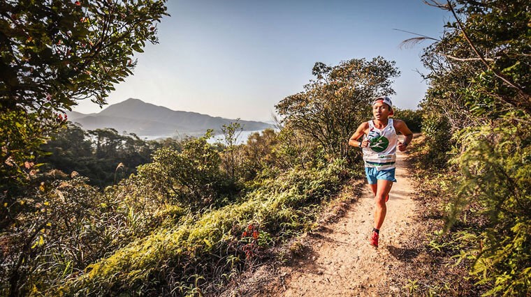
Hong Kong 100 Ultramarathon
About
If you’re seeking an ultramarathon to take your breath away both literally and figuratively, the Hong Kong 100 Ultramarathon (HK100) was made for your bucket list.
Since the inaugural race in 2011, runners have been amazed by this spectacular and enchanting course that combines views of pristine white-sand beaches and dense forest, all incredibly close to the vibrant metropolis of Hong Kong – Asia’s thriving financial centre.
With ancient jungle and concrete jungle only a short drive from the other, this course offers a unique perspective of the natural world just outside Hong Kong city’s door, without ever setting foot among the skyscrapers themselves.
This 103km (64 mile) race is one of contrasts – city side by side with the natural world, and inspirational beauty with a dose of pain, yet worth every moment.
A special mention has to go out to the volunteers, with their helping hands and smiles of encouragement making each of the checkpoints an uplifting experience – not only to refuel, but to re-discover your motivation and mental resilience when fatigue sets in.
With heat and humidity increasing the hydration demands of runners, each checkpoint is a welcome stopover. However, it’s also essential to be prepared with additional layers to combat the chilly conditions on the mountain summits.
Because of majestic races like the Hong Kong 100 Ultramarathon, Hong Kong has made its name as a go-to destination to journey off the beaten path and come up for fresh air, among 400 million year old mountain ridges.
The Course
Beginning in Pak Tam Chung on the Sai Kung Peninsula, the Hong Kong 100 Ultramarathon is a breathtaking feast for your eyes, and just as breathtaking for your lungs as you admire its beauty and conquer its challenges.
The MacLehose Trail – one of Hong Kong’s most well-known trails that’s both strenuous yet visually spectacular, is the heart of the Hong Kong 100 Ultramarathon. This course has been fine-tuned to showcase the dream-like scenery of this mountainous environment, diverging off the trail in sections to do so.
Home to Hong Kong’s most memorable scenery, the Hong Kong 100 Ultramarathon is a superb experience and one that truly engages the senses – with crashing waves offering a soothing soundtrack to the vibrant cacophony of runners.
The course quickly transitions from the feel of a road marathon, to a narrow singletrack climb, compressing runners into a smaller space as it directs you around East Dam’s western side.
Smooth, rolling transitions between dense forests and wider road ease you into the race in the first 12km (7.5 miles). You’ll be greeted to stunning views as you journey across two monumental dams, with rocky islands emerging from the crystal blue sea below.
The tree coverage clears to uncover a stunning view of the picturesque white beach of Sai Wan, and the colossal mountains hugging to its sands. You’ll run across the beach itself, before the Sai Wan Shan hill climb. Ham Tin beach welcomes you on the descent, alongside the first checkpoint, then the second climb emerges – Nga Yee Shek Shan.
It’s an arduous effort hiking up the hill’s steep sides, especially when the temperature climbs. From there, the forest seems to close in, until you uncover the second checkpoint. The terrain between checkpoint 2 and checkpoint 3 is seemingly flat, but surprisingly technical as you navigate around gnarled roots and hop from stone to stone.
Beyond checkpoint 4, Kai Kung Shan mountain treats you to spectacular scenery of islands rising from a tranquil, seemingly limitless sea before the descent on the other side. Checkpoint 5 gives you an opportunity to recover, and night is likely to follow.
The coastline-hugging route in the first half transitions inland in the second half, where the challenge truly begins, with mountains of steps - both ascents and descents - testing your leg strength. The terrain guides your stride length, forcing a shift in your pace.
After a wide flat road, a long uphill stretch up Ma On Shan mountain to the ridge offers an enchanting view of the glistening city lights. Checkpoint 6 at Gilwell Camp follows, with a long stretch of running along the ridge until reaching Beacon Hill aid station.
A fast, steep and snappy downhill follows before Shing Mun then Needle Hill, followed by another checkpoint as the night transitions to morning.
The hills have been referred to as “savage” by competitors, but the reward for this pain is stunning views that will be cemented in your memory as you ascend the highest peak in Hong Kong, Tai Mo Shan, towards the end of the race.
From this viewpoint on a clear day, Hong Kong city feels just an arms-length away, as the city skyline seems to inch closer – fuelling your motivation as you take on the final dash downhill from Route Twisk to the finishing chute on the misty descent.
Hong Kong 100 Ultramarathon: Need-To-Know
Main Race
- First Event: 2011
- Distance: 103km / 64 miles
- Cumulative Elevation: 5314m
- Cut Off Time: 30 hours
Other Events
- 33km - The Third
- 56km - Half
Total Participants
3000
Race Dates
18 – 20 Jan 2024 (Please check the official website to confirm dates and times of your specific event)
Official Website
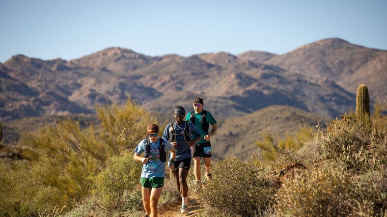
Black Canyon Ultra: 100K
About
When the word 'desert' comes to mind you may not expect to find 'beautiful' in the same sentence, but the Black Canyon Ultra is known for its stark beauty – the dramatic, fine red dust that’ll imprint its memory on both your heart and trail running shoes.
Nestled among Arizona's Bradshaw Mountains to the west, this trail run doesn’t only reveal what the enchanting Sonoran Desert trails have to offer, but uncovers more about yourself in every stride as you overcome its challenges – where if unprepared, you’ll carry the weight of the elements for 100km.
Presented by Hoka, the Black Canyon Ultras are composed of two ‘sister’ races held on consecutive days – the 100K and 60K – and the terrain is wildly diverse, from singletrack trails to jeep tracks to rocky descents to ignite your adventurous spirit.
This route has heritage significance, traditionally used by pre-historic Native Americans for trade and travel, connecting local settlements, and giving you a glimpse of the past when stagecoaches and livestock traversed its winding undulations. You’ll set foot on the traditional lands of the Yavapai Apache and the Hohokam, with saguaro cactus – some potentially over 150 years old - standing as silent sentinels, witness to your journey.
The Black Canyon Ultra 100K takes you on a journey consisting of multiple river/creek crossings – with 55km in the most notable. It gives you a sense of the power of water, particularly in the stark contrast to the desert landscape.
Exposure to the sun on this course can be a real risk, as shade is so sparse as to be absent – and depending on your luck, the desert may envelop you in soaring temperatures by day and chill your muscles by night.
It’s critical to be conscious of your hydration intake and fuelling strategy to avoid overheating. Luckily, the aid stations aren’t a mirage – they’re a welcome stop to top up your electrolytes, grab a handful of snacks like pretzels or fruit, and soak in the enthusiasm of volunteers.
The Course
The Black Canyon Ultra 100K is a scenic point-to-point course that begins at Mayer High School and heads towards Emery Henderson Trailhead in Phoenix, offering ever-changing terrain – from saguaro forest to steep, rugged canyons - that are just as captivating as they are challenging.
With a net elevation loss and cumulative elevation of 1250m, the course is deceptive on paper, with many runners lured into a false sense of confidence of its runnability.
The feel of it is entirely different to what these numbers may suggest – particularly in the second half of the course where you’ll be challenged by punishing technical terrain and leg-numbing inclines. Even ultra veterans will be tested here.
Country roads for the first 5km transition to a dirt tracks then singletracks, with the technical nature of the course gradually unveiling itself with the increasingly rocky terrain.
You'll encounter the Antelope Mesa aid station just after the 12km mark (7.7 miles in), followed by running on a switchback single track meandering through the desert with saguaro cactus towering around you. Larger still, the distant mountain ranges cast a shadow over the land and hold you in marvel of the desert landscape.
On rainy days, this initial stretch can transform the dirt road to mud – where the ground itself seems ravenous to soak up every drop - forcing runners to navigate the slushy conditions as the mud envelopes your trail running shoes.
Just before the 20km mark (at 12.9 miles in), the Hidden Treasure aid station emerges, followed by Bumble Bee aid station (31.2km / 19.4 miles in).
The first 30km may 'trick’ runners into setting a faster-than-ideal pace, being primarily downhill. This is definitely a time to slow down and smell the cacti, as your energy is best reserved for the more severe, rocky terrain and ascents that are yet to come.
It's also important to note that if care isn't taken between the 11km - 32km mark or so during the gradual downhill, your muscles may pay the price later in the race, when unforgiving uphills await you further down the track.
From Bumble Bee aid station, it's a short stretch to Gloriana Mine aid station, being 38.6km (24 miles) into the race. Your proprioception is tested to its limits, with potential ankle-rolling territory meaning every step has to be calculated, rather than running by feel or instinct.
A challenging descent follows, then you'll be rewarded by the first river crossing - giving you the opportunity to cool off before the painful incline on the other side.
With 50km of beautiful and brutal mountainous desert behind you halfway in, the heat will be taking its toll. At 58km in, another notable climb takes your breath away as you head towards Black Canyon City aid station, then Cottonwood Gulch aid station about 14.5km (9 miles) after. The trek in between is challenging, with the second largest climb awaiting you in scorching hot conditions.
Crossing the Agua Fria River multiple times in this stretch, wet feet are a part of the challenge – especially in combination with hot weather that can increase friction and discomfort. Many ultra runners take the opportunity to take a soak in the river to help restore their internal body temperature to a race-ready level.
After Cottonwood Gulch aid station (74.4km / 46.2 miles in), the journey to Table Mesa aid station at the 82km (50.9 miles) mark offers spectacular scenery of the desert, with switchbacks on the downhills for more runnable terrain before a snappy climb to the aid station itself. Table Mesa aid station offers a good opportunity to switch to dry trail running shoes, as the three river crossings of Agua Fria are now done and dusted.
With the dark closing in and the cold to follow, the tallest climb of the race so far greets you. Being a gradual and steady ascent, on any other day this may be a relatively comfortable experience. However, on race day on beat up legs, it's a tremendous challenge. By this point, the headlamps of your competitors start to speckle across the vast desert.
After undulating terrain with a combination of a larger climb and smaller climbs ahead paired with their respective descents, you'll find Doe Springs, the final aid station around the 94km (58.6 miles) mark.
Within the final stretch, music and the cheers of the crowd entice you forward to Emery Henderson Trailhead, with the finish line lit up like a runway to reward your determination.
Black Canyon Ultra 100K: Need-To-Know
Main Race
- First Event: 2014
- Distance: 100km / 62 miles
- Cumulative Elevation: 1250m
- Cut Off Time: 20 hours
Other Events
- 60km
Total Participants
1500
Race Dates
10 – 11 Feb 2024 (Please check the official website to confirm dates and times of your specific event)
Official Website
https://aravaiparunning.com/network/blackcanyon/
North Face Transgrancanaria
About
The North Face ‘Classic’ Transgrancanaria is a spectacular clash of climates and environments – an island race that packs in photogenic beaches, rocky mountains, vibrant pine forest, stark desert and picturesque Spanish villages.
As Spain’s inaugural ultra race, launched in 2003, the North Face Transgrancanaria put Spain on the map in regards to showcasing its beauty and has attracted the best runners on the globe. Set on the island of Gran Canaria, just 100km from Africa and 1000km from Europe, this race invites you to explore one of the world’s most uniquely diverse landscapes of the Canary Islands.
126km (78 miles) and featuring a positive elevation of 6804m, this trail race will challenge the most serious of runners. Not only will you battle hills, but cold nights, hot mornings and fluctuating temperatures.
It pays to be prepared for the unforgiving elements, with the potential for high winds and rain making rocky grounds even more slippery and perilous, and turning dusty trails into shoe-bogging mud. Needless to say, weather resistant layers and walking poles for stability when traction is sparse are advised.
Every moment of this race offers a new challenge – from singletracks, dirt tracks and gravel roads to navigating tortuously rocky grounds. On the starker mountainous climbs, it almost feels like you’re in another world with the mars-like terrain.
It’s easy to see why it can take over 13 hours for those leading the pack to finish the race, with a cut off time of 30 hours and high numbers of non-finishers. Your physical endurance, mental resilience and ability to adapt to changing environments will be tested.
The Course
Running from north to south on the stunning Gran Canaria island – from beach to summit to beach - this ultramarathon is beautiful torture on your mind and body and opens your eyes to the power of nature.
Kicking off on the sandy Las Canteras beach with a nocturnal run, the initial stretch welcomes you with the sounds of waves crashing on relatively flat sand and refreshing sea breeze. To avoid running with soggy feet and setting yourself up for blisters this early in the race, it’s best to stay clear of the water that teasingly laps at the sand.
From the beach, the route takes you inland up a runnable incline of a few hundred metres, followed by a rocky, dry canal that’s a real test of your proprioception, particularly with only the eerie beam of headlamps to light the way.
This is true ankle-spraining territory – especially with loose rocks underfoot in the dark - where prioritising patience should come before setting a faster pace. You’ll feel relieved when the track widens to help avoid congestion or collisions with your fellow runners.
After the first 30km (18.6 miles) the race shifts up a gear in terms of difficulty – where steep rocky inclines and declines may motivate you with the challenge they offer, or de-motivate you with the pain on your feet.
Mountainous, winding ridges force you to stay sure-footed, with a lapse in concentration potentially perilous with the severe drop below. When the sun rises, it’s an absolutely enchanting scene when the light touches the mountains, with every summit photo-worthy.
You’ll reach Roque Nublo after a memorable, brutally steep climb – a rocky monolith set among the volcanic landscape at the heart of the island, before continuing on forest paths that snake around the mountains.
You'll be challenged by technical terrain dotted with jagged rocks on an incredibly steep climb, and grimace through the pain as you conquer more rocky riverbeds that are guaranteed to beat up your feet. That’s just a taste of what this race has to offer before Maspalomas beach welcomes you at the finish line to the cheers of the crowd.
Looking back, many of North Transgrancaria’s finishers have a complicated relationship with this monster of a race – respecting it for its beauty and brutality.
North Face Transgrancanaria: Need-To-Know
Main Race
- First Event: 2003
- Distance: 126km / 78 miles
- Cumulative Elevation: 6804m
- Cut Off Time: 30 hours
Other Events
- 12km - Promo/Youth & Family Trail
- 21km - Starter
- 46km - Marathon
- 84km - Advanced
- 5.5km - VK El Gigante (Vertical Kilometre The Giant)
Total Participants
3500
Race Dates
21 – 25 Feb 2024 (Please check the official website to confirm dates and times of your specific event)
Official Website
https://transgrancanaria.net/en/
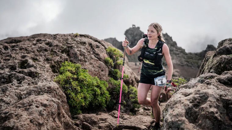
Mt. Fuji 100
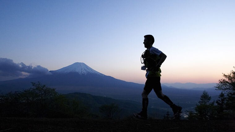
About
Thousands of trail blazers, adventure seekers and globetrotters have made the pilgrimage to Mount Fuji – home of Japan’s tallest peak that’s enriched with spiritual significance.
This breathtaking natural monument and symbol of Japanese culture, blossoming with thousand year old heritage, offers adversity and memorable beauty for those that take on Mount Fuji 100.
This 165km (102.5 miles) race based around this active volcano, just 100km southwest of Tokyo, will inspire and challenge you as you step foot on its surrounding, majestic landscape. It isn’t purely about endurance – it’s about getting close to nature and its obstacles to unveil your inner strength.
It feels like a surreal and sincere honour to be among the dense, enchanting forest and rocky trails surrounding the cultural icon of Mount Fuji. The tranquil environment offers a balance to the staggering physical demands this race offers – with a cumulative elevation of 7574m to test your muscles and mind.
Well-rounded runners discover themselves here – with some hiking and rock climbing experience absolutely an advantage, honest to the mountainous landscape. Your triumph and struggle is witnessed by Mount Fuji itself – an ever-present entity at the heart of the Japanese people and your journey.
The Course
The course starts and finishes within the Yamanashi province. Fujiyoshida, a small town with a long history as a textile producer (over a thousand years) and the closest city to Mount Fuji, marks the beginning of your journey.
With 25km (15.5 miles) of fairly flat terrain with only gentle rises and falls in elevation, the Mt. Fuji 100 eases you into the more aggressive challenges to come. Southwest of Mount Fuji’s base, you’ll traverse roads through dense forests lush with cypress and cedar.
The trail transitions into mountainous terrain as you head towards Mt. Fuji’s western side, where the Tenshi Mountains will challenge you. For runners that did not pace themselves to prepare for the steep hike ahead, this terrain can be a real adversary both to your legs and your digestion – no matter how beautiful. The scenery is just as enchanting by night, when rows of headlamps light up the darkness like wistful fireflies.
The serene Lake Shoji signifies the halfway point, before continuing on to the eerily beautiful, moss-veiled Aokigahara Forest (referred to as the Sea of Trees), thick with twisted canopies of branches, exposed, gnarled roots and volcanic rocks.
This atmospheric, 1200 year old forest took root in sediment-covered lava in an area that was once Senoumi Lake to the northwest side of Mount Fuji, sometime after the volcano erupted in 864. The lake is now divided into the Lake Saiko and Lake Shojiko of the modern world.
Following the infamous Aokigahara forest, you’ll conquer Lake Yamanaka’s surrounding mountains before ascending Mount Shakushi. This is Mt. Fuji 100’s most arduous and technical challenge, where trail running transforms into rock climbing.
Located northeast of Mount Fuji, the Fujiyoshida aid station is a welcome final stopover, to enjoy an udon, before battling the 15km that offers a relatively kind downward stretch on your body down a gentle ridge, the crisp sunlight at dawn enticing you to the end.
Mt. Fuji 100: Need-To-Know
Main Race
- First Event: 2012
- Distance: 165km / 102.5 miles
- Cumulative Elevation: 7574m
- Cut Off Time: 45 hours (Please check official website to confirm the cut off time for your specific start time)
Other Events
- 69km - KAI69k
Total Participants
3200
Race Dates
26 – 27 April 2024 (Please check the official website to confirm dates and times of your specific event)
Official Website
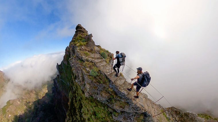
Madeira Island Ultra-Trail (MIUT)
About
An island race of a lifetime, the Madeira Island Ultra-Trail (MIUT 115) is Portugal's paradise for mountain runners and adventure seekers that don’t shy away from a technical challenge. You’ll be running alongside the top trail runners on the globe.
Running from west to east, from sea-to-sea across a volcanic landscape, the topography of this island isn’t for the faint of heart, with epically steep terrain. In fact, this ultramarathon takes you through the most aggressive terrain the island has to offer, traversing its highest points. Seamlessly limitless steps feel at home within the natural terrain.
It is a privilege to witness this beautiful and treacherous island unfold before you – and Madeira Island Ultra-Trail is designed to showcase its most enchanting scenery. The island is unique, both in its heritage sites and wildlife.
Needless to say, high traction trail running shoes that can bite into terrain from mountains to mud, and a waterproof running jacket to protect against the chill at higher elevations, are a must.
The climate presents its own challenge, welcoming humid and temperate conditions with its close proximity to Morocco, about 600m off its coast, centred in the North Atlantic Ocean.
The Course
The Madeira Island Ultra-Trail begins at sea level at Porto Moniz and ends at sea level at Machico. In between, you’ll experience ascents and descents like no other, that make this ultra run best suited to adaptable runners and those with alpine experience.
The first phase will be run at night, beginning with the north coast’s meandering footpaths and levadas (aquaducts) that offer a snapshot into what life may have been like for the inhabitants of the island, potentially dating back to the 15th century.
You'll head towards Paúl da Serra, Madeira Island's largest plateau, located to the west. Your sure-footedness will then be tested with the first climbs in the forested area of Fanal. Fanal itself has an alluring aura, a fairytale-like beauty among the fog-veiled, twisted branches. Fanal is followed by a challenging downhill to Chão da Ribeira that is honest to the technical challenge the entire MIUT 115 represents.
The arduous ascent to Estanquinhos follows, before being spurred on by the crowd as you cross the bridge of the Ribeira da Janela, Madeira’s longest river, formed in the heart of the mountains. The adventure continues with the epic descent to São Vicente, then a journey through the dense Laurissilva Forest wrapping Chão dos Louros Forest Park, as you ascend to Encumeada.
Within the central mountainous massif, one-of-a-kind scenery awaits you in the second phase from Encumeada to Areeiro. From the hidden gem of Curral da Freiras, the journey to the islands highest peaks, Ruivo and Areeiro, truly begins – but of course, not without a challenge.
The long and arduous climb rewards you with memorable views of the multi-faceted landscape, complete with plateaus, crests and valleys interwoven with streams. From this height, you feel like you are veiled in an ocean of clouds, with the picturesque summits virtually mythical in their beauty.
The segment between Ruivo and Areeiro is what attracts many to the mesmerising island of Madeira. Here, the most endangered seabird of Europe, the Zino’s petrel (Pterodroma madeira) makes its sole nesting site on the entire planet. It feels like an absolute privilege to be here.
The third phase of the race begins at Pico do Areeiro is primarily downhill, broken up with some ascents. You’ll pass in close proximity to Poço da Neve – a site with its own unique heritage, followed by Portela, with course transitioning to more rolling terrain.
You’ll head towards Porto da Cruz on old footpaths, ascend to Larano, and race to Boco do Risco. For those who encounter Boca do Risco in daylight, the views are spectacular, with the sea wrapping to the monolithic cliffs.
Heading towards the levada of Caniçal, the finish line isn’t far off. Your muscles can soak in some well-deserved relaxation while your eyes soak in the enchanting view of the city of Machico nestled in the valley, where the finish line waits to greet you.
Madeira Island Ultra-Trail: Need-to-know
Main Race
- First Event: 2008
- Distance: 115km / 71.5 miles
- Cumulative Elevation: 7100m
Other Events
- 16km
- 42km
- 60km
- 85km
Total Participants
3000
Race Dates
27 – 28 April 2024 (Please check the official website to confirm dates and times of your specific event)
Official Website
https://www.miutmadeira.com/en/
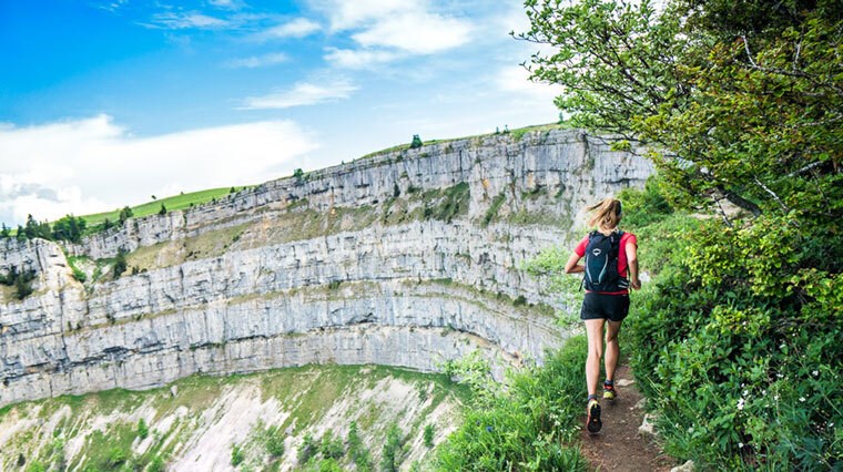
Swiss Canyon Trail 111K
About
The Swiss valley of Val-de-Travers is the ultimate destination to come up for fresh air – with the Swiss Canyon Trail 111K itself offering a picturesque and painful journey through a mountainous and scenic slice of central Europe ever since its launch in 1994.
It’s considered the top of the podium when it comes to the racing scene in central Europe, praised for its organisation and enchanting, fantasy-like scenery unique to the mountainous trails of the Swiss Jura.
It’s also the setting of the Swiss mountain running championships – and for good reason, for this epic race offers a multitude of ascents and descents - aggressive, rugged and inspiring. You won’t just hike or run over these trails – you’ll climb them – an exhilarating and unforgettable experience over brutally technical terrain.
Adversity naturally comes with the 5350m of cumulative elevation. There’s 3 major climbs, but there is no one summit that defines this race. The ever-changing scenery and terrain, from cliffs to canyons to waterfalls and lush forests with a mythical presence, means the highlights are bountiful as you traverse the Swiss valley.
The Course
With a 5am start, the first 12km of the Swiss Canyon Trail 111K supports a relatively snappy pace, although it’s best to reserve your energy for the aggressive climbs – both in incline and distance – yet to come after the first aid station.
A forested climb, about 700m in elevation, awaits you, with the foliage clearing at the foggy summit and substantially cooler temperature compared to the land below. At 20km (about 12.4 miles) in, the second aid station comes into view and from here until the third checkpoint, downhill and flat terrain vary the conditions for your muscles. The technical difficulty of the downhill rises as you approach the third aid station.
The journey to Le Chasseron, the highest peak of the Swiss Canyon Trail 111km has you conquering 860m of elevation in 11km (6.8 miles). The downhill is a potential turning point of the race, encouraging speed for skilful mountain runners equip for the technical terrain, heading towards Vuiteboef.
A monstrous climb – the final of the 3 major points of elevation in the race – follows, with 950m of vertical effort within 10.5km (6.5 miles). With 50km already behind you and fatigue settling in as you approach the halfway point, this climb is both brutal and beautiful. It rewards you with idyllic scenery surrounding the mountainous landscape of Aiguilles de Baulmes, a climb interlaced with rugged limestone rocks.
What goes up must come down, and the severely steep slope doesn’t disappoint. As a matter of safety, ropes have been attached, with a slip off the mountain a very real risk. Patience over pace is essential here.
With the most challenging ascents and descents behind you, you can breathe. The dramatic shifts in elevation experienced in the first half – true mountain running territory – gives way to climbs that are flatter and less aggressive.
Nevertheless, the fatigue of having already covered an incredible distance and elevation, will make the flats more challenging than they appear. Here however, you may be able to flow into a comfortable, smooth-flowing rhythm. The inspirational scenery will drive you forward.
Further down the trail, you’ll run down a forest road before a final climb. The descent is a truly liberating experience as you realise this is the final stretch – with emotions running high and volunteers cheering as the town before you is unveiled and with it, the finish line.
Swiss Canyon Trail: Need-to-know
Main Race
- First Event: 1996
- Distance: 111km / 69 miles
- Cumulative Elevation: 5350m
Other Events
- 16km
- 31km
- 51km
- 81km
Total Participants
3000
Race Dates
7 – 9 June 2024 (Please check the official website to confirm dates and times of your specific event)
Official Website
https://swisscanyontrail.com/en/
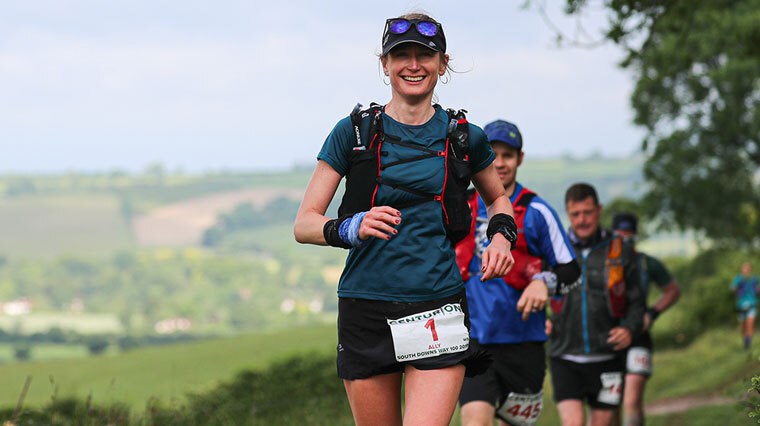
South Downs Way 100
About
Blossoming with the charm and history of southern England, the South Downs Way 100 is 160km (100 miles) of picturesque, far-reaching views complete with everything from idyllic villages to ancient Roman forts.
The tranquil tea rooms and thatched pubs that the United Kingdom is famous for, all make their home within this countryside – but this cosy and comforting setting isn’t without its challenges as you transverse the chalk ridgeway and escarpments.
You’ll feel connected to an expansive history as you journey down routes and rolling hills that have been touched by thousands of years of travellers. Needless to say, numerous ascents and descents form the character of this course. Also true of the southern England’s countryside, alongside other trail runners, sheep and cattle may also be witness to your journey.
Alongside the undulating landscape, the ever-changing weather itself can be a source of adversity – with the potential for rain to result in less-than-ideal terrain, with mud or slippery chalk potentially accompanying rocky stretches.
South Downs is breathtaking. However, besides pockets of tree coverage, the beautiful open trails leave you exposed to the elements. With shade sparse, your pre-race preparations are crucial to ensure you stay adequately hydrated for the duration of your ultramarathon.
The Course
Nestled on the outskirts of Winchester, the capital city of Saxon England, you’ll find the starting location at Matterley Bowl. Running east from Winchester to the finish point in Eastbourne Sports Club Athletics Track, the South Downs Way 110 is an enlightening experience as the landscape unfolds. Eastbourne itself is located on the coast of the English Channel – a picturesque coastal town and the United Kingdom’s sunniest destination.
The course begins with a 6km (3.7 mile) loop through Matterley Estate, then heads to South Downs Way – a national trail that immerses you in the heart of South Downs National Park. Singletrack trails weave through lush foliage, until the 10km (6.2 mile) mark where the vegetation gives way to more open scenery.
The first half of the race welcomes you with flats and gentle, runnable undulations. The very first hills come in at 3km (1.9 miles) and 11km (6.8 miles) – reminding you to keep a reserved, steady pace before the second half, where aggressive uphill and downhills can feel like you’re trying to conquer a roller coaster on foot.
The Washington aid station gives you an opportunity to refuel. From here, the hill fort of Chanctonbury Ring, adorned with a crown of beech trees, is a site of historical and archaeological significance. It follows after a significant climb, offering tranquil and expansive views of the countryside of South Downs.
A larger downhill takes you to the linear village of Botolphs, before bracing for another ascent – long and steep in its nature. Wider trails and shorter ascents and descents allow you to flow into a smooth running rhythm.
From Clayton Windmills, you’ll journey through Housedean Farm. From this point, four more large climbs will test your legs before the finish line.
About 12.2km (7.6 miles) of uphill effort awaits for you between the Southease and Alfriston checkpoint.
Along the ridge following after Firle Beacon hill, your journey can seem virtually endless, until Alfriston checkpoint at 76km (47.2 miles) welcomes you with refreshments. Your spirits will be uplifted and the finish line will start feeling more tangible. The support from volunteers is next to none to refuel not only on nutrition, but your motivation.
From here reaching Jervington - the final checkpoint before the finish line - feels like an absolute accomplishment, with stunning views that help you soak in how far you’ve come, before taking on a tough, steep downhill.
The very last hill is extremely painful on fatigued muscles. The reward however, keeps you honest to your goals. Knowing the reality that your journey is nearly complete will energise you.
The course leads you to the Eastbourne Sports Club Athletics Track – where a final 400m loop is the only thing between you and the finish line. Here, the supportive cheers of crowd and family nurture a spring in your step that you believed had long since faded.
South Downs Way 100: Need-to-know
Main Race
- First Event: 2012
- Distance: 161km / 100 miles
- Cumulative Elevation: 3800m
Total Participants
700
Race Dates
8 – 9 June 2024 (Please check the official website to confirm dates and times)
Official Website
https://www.centurionrunning.com/races/south-downs-way-100-2024
Quebec Mega Trail 100
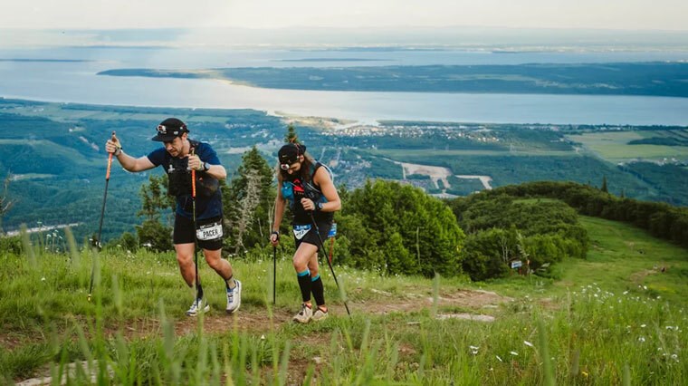
About
The Quebec Mega Trail is at the pinnacle of trail running in Canada – with the 160km (100 mile) race the most prestigious among a line-up of 10 events, covering distances from 1km (for little trailblazers) to the 100-miler itself to cater to a variety of skill levels.
Your adventurous spirit will be given wings among the raw and rugged beauty of Canada - consisting of luscious and untamed forests, picturesque lakes and steep ascents to technically challenge you and your quads from Charlevoix to Côte de Beaupré.
Top trail runners and trail enthusiasts gravitate to this event that showcases the vibrant and welcoming city of Quebec, which is both Canada’s only French-speaking province and one of its oldest cities. It cultivates an instinct to travel, explore and be apart of something greater as you take on the reward and challenge that is Quebec Mega Trail – packing in more than 6500 metres of cumulative elevation within a wilderness like no other.
The banks of the St. Lawrence River and passage through the Sainte-Anne River canyon offer a trail runner's paradise, allowing you to get closer to nature – including overgrown trails, forested singletracks, majestic waterfalls and breath-taking views after the mountainous trek to the top of Mont-Sainte-Anne. The Laurentian Mountain range will both inspire and challenge you.
The weather itself almost forms a tangible character, with the potential for rain and humidity transforming the terrain to unforgiving mud, and waist deep creek crossings, naturally adding minutes to finishing times.
The Course
The Quebec Mega Trail 100 is a point-to-point course beginning at the Saint Lawrence River’s northern shore at Baie-Saint-Paul – a heritage town and tourist destination with inspiring scenery and cultural charm.
Heading towards Le Masstif with a gentle climb, the first 5 -6km stretch offers relatively flat terrain. You’ll pass an open field, climb through trees and encounter the first aid station (water only) after a descent then continue on to Halte de l’arche.
By 19km (11.8 miles) in, you’ll be welcomed by a more substantial aid station to re-hydrate and refuel. The trail passes beneath the highway before the road steers to the south towards more authentic trail running territory.
At 28km (17 miles), another aid station provides opportunity to fill your hydration pack before immersing yourself in the forest to complete the climb to Le Masstif after another uphill effort.
The Le Massif aid station is at the 39km (24 mile) mark. From here, the roads tend to be wide, if overgrown. The Cap du Salut aid station, 52km (32 miles) in, helps you refuel not only on nutrition, but on motivation with the supportive vibes.
In wet conditions, the trail becomes more arduous – bog-like in nature – both muddy and rocky presenting a genuine trip hazard and an obstacle to maintaining a smooth rhythm. From the Cap Gribane aid station, the halfway mark is only 15km (9 miles) of effort – but feels endless as fatigue settles in.
As you approach the Saint-Tite-des-Caps aid station, beneath the highway a creek crossing offers another challenge. Rock-hopping over the water, you can breathe a sigh of relief knowing you’ve conquered half the race and can take a moment to rest and recover.
Lush vegetation gives way to open air – if only for a moment - as you progress towards Auberge du Fondeur. You’ll re-enter tree coverage, with the Mestachibo Trail to come, taking you through the Sainte-Anne River canyon. Undulating trails keep the terrain varied, until a glimpse of the Sainte-Anne River can be seen through the tree coverage after a challenging downhill.
You can put your feet up momentarily, because trail runners don’t run across the river – they take a raft across via ropes, aided by a friendly crew to support your journey.
Beyond, the trail is rugged and rough with a combination of aggressively steep stairs and rocky downhills, the river feeling like an ever-present guide as you spot it through the trees.
The Mestachibo aid station sits around the 92km (57 mile) mark, followed by a challenging climb. You’ll navigate over rocks and boulders, continuing on the trek to Mont-Sainte-Anne. The majestic Jean-Larose waterfall provides a reward for your senses, while steep, seemingly endless stairs continue the challenge for your legs and lungs.
The Mont-Sainte-Anne aid station gives you a moment to take care of your muscles and running nutrition, before the short yet epically steep climb to the top. Mont-Sainte-Anne is merciless and without switchbacks so the climb feels entirely vertical. Your legs are likely to feel like lead after this climb if they don’t already, and the flat at the top and following aid station is more than welcome.
Journeying downhill halfway down the mountain and back again, this loop is the ultimate test of your quads – with the descent obviously just as steep as the ascent. At the bottom, a flat section lets your legs take a breather before more hilly terrain.
At the Auberge du Fondeur aid station, another opportunity to refuel awaits before heading to Montée Saint-Hillaire – a path riddled with overgrown roads and mosquitoes. There’s a small aid station nestled in the forest before reaching the St-Hilaire aid station, then the race loops back to Auberge du Fondeur, 149km in (92.5 miles).
The last 10km (6.2 miles) offers a combination of climbs and descents – likely with the dark pressing in. With just 1km to go, a creek crossing follows a steep trail. Embracing wet trail running shoes for the final stretch, you’ll conquer another creek before the trail transitions to paved road, before the finish line at the southern base of Mont-Sainte-Anne.
Quebec Mega Trail: Need-to-know
Main Race
- First Event: 2012
- Distance: 160km / 99 miles
- Cumulative Elevation: 6500m
Other Events
- 1km (kids' run)
- 6km
- 10km
- 15km
- 21km
- 25km
- 50km
- 80km
- 110km
Total Participants
3300
Race Dates
5 – 7 July 2024 (Please check the official website to confirm dates and times of your specific event)
Official Website
https://ultratrailcanada.com/en/
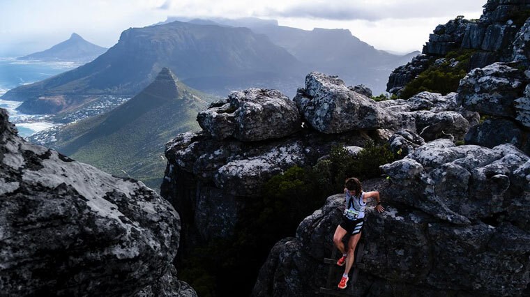
RMB Ultra-Trail Cape Town
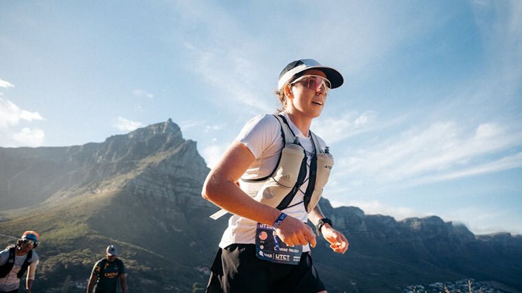
About
The RMB Ultra-Trail Cape Town 166km (100 mile) is the flagship race of Africa and is celebrated across the globe. It takes you on an epic journey through the southernmost point of the continent, enriched with both views of the metropolis of Cape Town, and the remote tranquillity of the Atlantic coast.
With 7516m of elevation gain packed within the 166km distance – this race is more than an adventure, it’s a representation of the strength of the human spirit. With a 45 hour cut off time, it’s no secret that this race will challenge and inspire you.
Your inspiration will be nurtured as the landscape unfolds, including some of Africa’s most treasured landmarks. Among them are the 'Twelve Apostles' – the breathtaking peaks of Table Mountain, which delivers scenic views of the beautifully rugged coastline from the flat summit. You’ll both climb monolithic mountains and coast over the sand of stunning beaches within the 166km of adversity and beauty.
Runners across 47 countries participate, with the race clocking up over 2000 competitors, having boomed in popularity since its launch in 2014. The momentous race is just one event in Cape Town’s festival of running – a celebration spanning a week and consisting of multiple opportunities to stretch your legs and compete.
Runners that brave the RMB Ultra-Trail Cape Town, one of the key ultramarathons on the global map, are rewarded with a life-long achievement. It's invigorating to not only witness such a magnificent landscape on foot, but to be a part of the legacy of this prestigious race.
The Course
Beginning from Cape Town, this 166km course takes you from the northern mountains of the Mother City of South Africa to the southern mountains and consists of four steep and leg-numbing climbs.
An uphill trek from the city takes you to Signal Hill, rewarding you as you reach the surrounding area of Lion’s Head with breathtaking views of both the Atlantic Seaboard and the city.
You’ll conquer the north face of Table Mountain midway, then be tested with a severe incline – the longest of the ultra run – as you head towards Platteklip Gorge, continuing the Table Mountain climb.
Just 25km (15.5 miles) from the starting point, your legs will feel like lead after already covering 1700m of the total 7516m elevation gain.
You’ll trek along the ridge of Table Mountain, followed by experiencing the Twelve Apostles foot first before heading to Llandudno Ravine. The descent is challenging and technical, and the Llandudno aid station is a welcome stopover to refuel and recover.
Sandy Bay offers flat and serene stretches along the picturesque coast – a pleasure for your eyes as well as your legs as you take in the scenery on kinder terrain. The stretch to Suther Peak will have you conquering 600m of elevation, heading to Karbonkelberg then Hout Bay aid station – the second notable climb of the race. East Fort and Blackburn Ravine follow, with the third steep climb greeting you as you journey to the Southern Peninsula.
The course transitions to more runnable terrain as night falls, from Silvermine’s southern trails to the aid station at Kommetjie. Stretching from Kommetjie to Noordhoek, 8km (5 miles) of flat beach helps revitalise fatigued legs
The forth key climb at Chapman’s Peak awaits you after traversing Chapman’s Peak Drive. Afterwards, it feels like you’re truly closing in on the finish line as you approach Constantia Nek through Manganese Mines and Vlakenberg.
You trek from here to Alphen Trail aid station through vineyards and the green belts of the city. More technical climbs awaits within Cecilia and Newlands Forests, with Rhodes Memorial only reached after a steep descent.
The final aid station is nestled just beyond the University of Cape Town – a last retreat before pulling out your dwindling energy reserves to take on the 10km (6.2 miles) remaining. Blockhouse and the lower traverse of Devil's Peak are reached through an arduous climb that’s rewarded with memorable scenery encompassing Table Mountain and Lion's Head.
From here, views of city (Cape Town) and sea (Atlantic Ocean) treat travellers to both the stunning cosmopolitan and natural marvels that Africa is bountiful in – a memorable end to an epic race as you complete the final stretch.
RMB Ultra-Trail Cape Town: Need-to-know
Main Race
- First Event: 2014
- Distance: 166km / 103 miles
- Cumulative Elevation: 7516m
Total Participants
2000
Race Dates
22 – 24 November 2024 (Please check the official website to confirm dates and times of your specific event)
Other Events
- 23km
- 35km
- 55km
- 100km
Official Website
https://www.ultratrailcapetown.com/
If you liked this, you'll love:
6 Major Marathons For Your Bucket List
6 Must-Run Marathons In Australia
Ultramarathon Nutrition & Hydration Guide: Carbs, Electrolytes & Caffeine
Mandatory Gear Guide: Everything You Need To Run An Ultramarathon